
This text has been translated by a machine and has not been reviewed by a human yet. Apologies for any errors or approximations – do not hesitate to send us a message if you spot some!
Soils are the foundation on which the entire edifice of terrestrial ecosystems rests. Far from being mere supports, they are in fact three-dimensional ecosystems, environments rather than surfaces, which are themselves alive and perform a series of ecological functions crucial to terrestrial life and therefore to human societies.
The aim of this fact sheet is to explain what soil is, and what functions it performs for living organisms and humans. It also explores how the artificialization of soils, i.e. their destruction by human activities, is a source of major risks.
Soil: an ecosystem in its own right, a planetary boundary
New horizons: seeing floors in three dimensions
All too often, soils are perceived as an inert surface on which terrestrial ecosystems and human activities are spread out, as if they were simply placed there. On the contrary, they are three-dimensional environments, with structures, compositions and characteristics that vary according to context.
If the ground is not just the surface of the Earth, the floor of our lives, then what is it?
Soil is a volume extending from the Earth’s surface to a depth marked by the appearance of hard or loose rock, little altered or little marked by pedogenesis.1. Soil thickness can vary from a few centimetres to dozens of metres or more. Locally, it forms part of the soil cover that extends over the entire surface of the Earth. It usually comprises several horizons corresponding to an organization of organic and/or mineral constituents (the soil). This organization is the result of pedogenesis and alteration of the parent material. It is the site of intense biological activity (roots, fauna and micro-organisms).
In other words, soils constitute the volume between the earth’s surface and the little-altered rock, generally referred to as bedrock. Between the two, the soil is structured into several levels, called “horizons”.
The six main categories of soil horizons
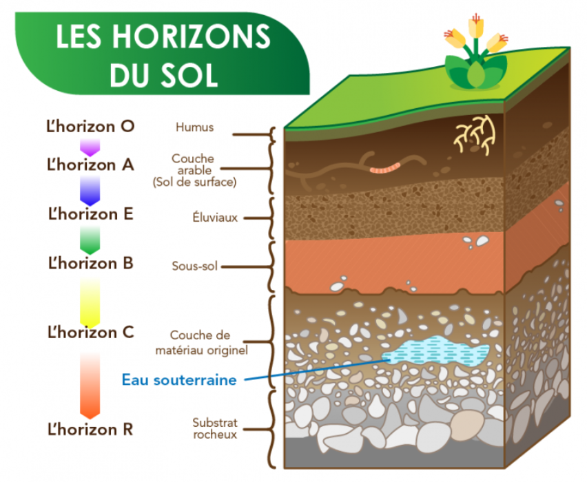
Source ParlonsSciences.ca using a normaals image via iStockphoto).
Schematically, we distinguish six categories of horizons2 depending on soil type and situation, these different horizons can take different forms.
- TheO horizon (or humus) is mainly composed of decomposing organic matter.
- TheA horizon, known as the arable horizon, is essentially composed of a mixture of minerals and decomposed organic matter – this is where plant roots develop.
- TheE horizon, known as eluvial, is a horizon in which a series of materials such as clay, iron, aluminum and organic matter are leached laterally or at depth. This horizon is found in humid conditions, for example in coniferous forests.
- TheB horizon, or subsoil, is made up of clays and minerals, as well as organic matter present in smaller quantities than in the upper horizons.
- TheC horizon, also known as the “original material layer”, contains fragmented but little altered rock, with very little organic matter.
- Finally, theR horizon (bedrock) is that of the bedrock, featuring rock masses such as granite, limestone or sandstone.
Soils, their structure and composition are diverse and can vary widely depending on the context.
In any case, soils are not just the surface layer rich in organic matter, and it should be stressed that their formation – or pedogenesis – takes place over particularly long timescales. The genesis of a few decimeters of soil takes thousands or even tens of thousands of years: soils are therefore a non-renewable resource on human timescales.
Soils are alive
Soils are oceans of life: one gram of soil contains around a billion bacteria of 2,000 to 10,000 different species. It is estimated that soil is home to around 25% of all animal species described.3ranging from microscopic organisms to vertebrates such as rodents, as well as numerous nematodes and springtails, tardigrades and mites, insects, arachnids and earthworms.
Soil biodiversity can be classified according to a size criterion4 microorganisms, then microfauna, mesofauna, macrofauna and finally megafauna, i.e. vertebrates such as moles and voles. This classification by size is shown in the diagram below.
Diagram of the various soil biodiversity groups classified by size
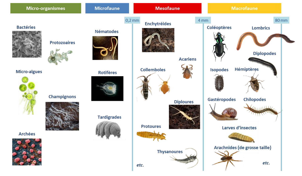
Source Quentin Vincent – Study of abiotic, biotic and functional parameters, and their interactions in neglected soils. PhD thesis – Université de Lorraine, 2018.
Biological interactions between all these species (prey-predator relationships, symbiosis, etc.).5 constitute the ecological functions fulfilled by soils, which benefit all terrestrial ecosystems, and hence humans.
The ecological functions performed by soils
In November 2024, Inrae published a report summarizing scientific knowledge on soil quality in which scientists distinguish six major types of ecological functions performed by soils:
- Regulating water quantity and quality
- Controlling contaminants
- Carbon storage
- Supply nutrients to the biocenosis
- Maintaining soil structure
- Supporting biodiversity
The ecological functions of soils
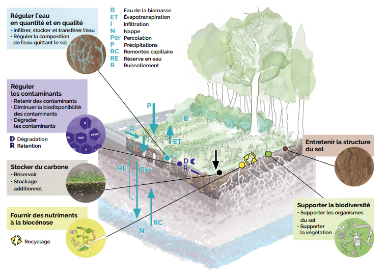
Source Préserver la qualité des sols : vers un référentiel d’indicateurs, INRAE, November 2024.
These ecological functions produce indispensable and irreplaceable services for human populations:
- Supply of food, fiber, fuel ;
- Climate regulation (via soil carbon storage) ;
- Water purification and contaminant degradation ;
- River regulation6Groundwater replenishment and flood control ;
- Maintaining biodiversity (e.g. soil fertility, pollination, pest control, etc.);
- Supply of materials (bio-sourced materials such as wood, cork, straw; and materials that make up the soil itself: topsoil, silt, clay, sand, etc.) and infrastructure support;
- Archiving information on natural and cultural history (e.g. fossil preservation).
Each of the above-mentioned ecological functions contributes in a differentiated way to several of the services from which humans can benefit. Scientific literature classically presents the links between soil ecological functions and ecosystem services in the diagram below.
The contribution of soil ecological functions to various ecosystem services
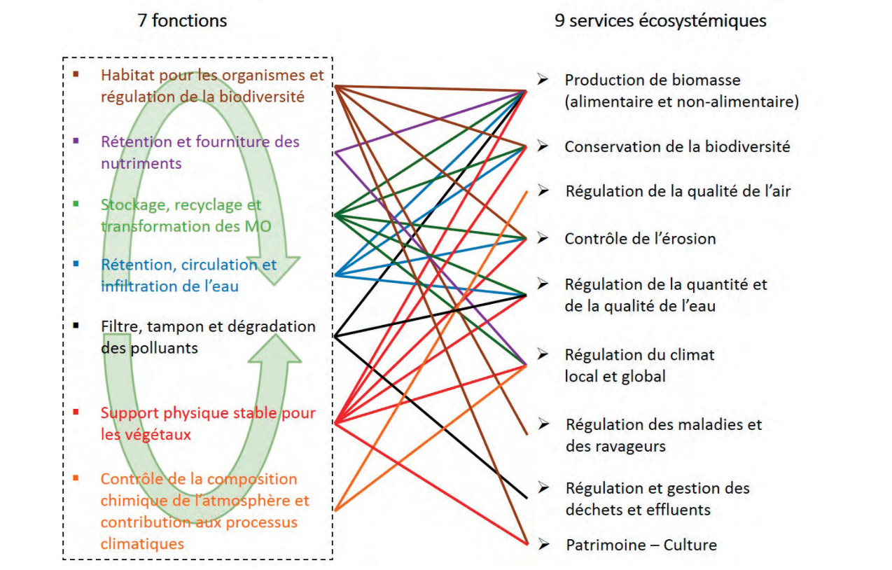
Source Calvaruso et al, Which soil parameters should be measured to assess functions and associated ecosystem services? Literature review and selection of parameters in participatory workshops, Étude et Gestion des Sols, Afes, 2021
Find out more
- Soils and their formation in temperate climates, Planet-Terre
- Fiches synthétiques de présentation des fonctions des sols et indicateurs associés, Cerema, 2022
- Les super pouvoirs des sols : des solutions pour la ville de demain (Comic strip) Cerema, 2023
- Des sols menacés mais pourtant vitaux, Cerema, 2023
Soil artificialisation: definition and trends
The notion of soil artificialisation was defined in law for the first time in 2021, thanks to the Climate and Resilience Act. Previously, the term “artificialisation” referred to the process of urbanization, whereby natural, agricultural or forested areas (ENAF) are developed for residential, economic, industrial or other uses.
The Climate and Resilience Act 2021 introduced two major changes:
- A definition of artificialisation based on the alteration of the ecological functions of soils, which goes beyond the purely surface vision limited to changes in use (consumption of ENAF).
- A target of Zero Net Artificialization set for 2050, and a goal of halving the consumption of NFA between 2011-2021 and 2021-2031.
These targets come at a time when the built-up area grew by 80% over the four decades preceding the law, four times faster than population growth.
The genesis of a concept: from ENAF consumption to soil artificialisation
In 1946, the Ministry of Agriculture launched its first survey of agricultural land use, based on cadastral maps. These were updated using aerial photography from 1962 onwards, and twenty years later, in 1982, the survey was extended to cover the whole country, becoming the Teruti survey (for “land use”).7. Initially, the monitoring of soil artificialisation was based on the desire to measure the loss of land available for agriculture, before being extended to natural and forested areas. This is how the notion of consumption of natural, agricultural or forest areas (ENAF) came about.
Thus, for decades and until 2021, the notion of artificialisation of land was not formally defined in law: previous laws only referred to “economical land management” or “preservation of space”.
This is the Climate and Resilience Act of August 22, 2021, which introduced into French law the definition of the notion of artificialisation of land, which it distinguished from the consumption of ENAF.
ENAF consumption is thus defined as “the actual creation or extension of urbanized areas on the territory concerned”.8 It is therefore a surface notion that concerns the change in land use.
The definition of soil artificialisation is more qualitative, focusing on the various ecological functions of the soil.
Artificialization is defined as the lasting alteration of all or part of a soil’s ecological functions, in particular its biological, hydric and climatic functions, as well as its agronomic potential, through occupation or use.
The introduction of the notion of ecological functions that can be wholly or partially degraded could have led to the idea that artificialisation would not be a binary notion (a soil either artificialised or not artificialised), but a gradual one – a more or less artificialised soil, some of whose ecological functions are altered while others remain.
However, this possibility was closed by the Climate and Resilience Act, which specified the types of soil considered as artificial or not, according to characteristics linked to their occupation or use.
“Within planning and urban development documents, where the law or regulation provides for targets to reduce the artificialization of land or its rate, these targets are set and evaluated considering as:”
“a) Artificialized a surface whose soils are either waterproofed due to building or surfacing, or stabilized and compacted, or made of composite materials;”
“b) Non-artificialized means an area that is either natural, bare or covered with water, or vegetated, constituting a natural habitat or used for cultivation.
Lastly, the law stipulates that the conditions for applying these definitions are to be laid down in a decree by the Conseil d’Etat, which in particular establishes a nomenclature of artificial soils and specifies the scale at which the artificialization of soils is to be assessed in planning and urban development documents.9
Different methods are used to measure land artificialisation
How is soil artificialisation measured in France?
In France, the Climate and Resilience Act introduced two distinct objectives:
- reduce the consumption of FFPE by 50% over the 2021-2031 period, compared with the previous decade
- Achieve Zero Net Artificialization (Objectif ZAN) by 2031, assessed on the basis of the nomenclature of artificial land use introduced by the Climate and Resilience Act.
For the 2021-2031 period, the monitoring of land artificialisation is therefore still carried out via the measurement of ENAF consumption.
As mentioned above, the measurement of ENAF consumption has historically been carried out in France by the Ministry of Agriculture via the Teruti survey, which became Teruti-Lucas in 2005 after adaptation to the European Lucas survey.10 This method is based on the observation of a sample of points on the territory, then statistically extrapolated. Today, these data are mainly used to obtain an overall view of land use and occupancy in France.
The reference method used today to implement targets for reducing the artificialization of land is the “land files” method. It is used to evaluate annual flows of ENAF consumption. The data are produced by Cerema11 based on analysis of changes in land use in property tax data. ENAF consumption can be tracked via the land artificialisation portal .
Local authorities have also developed methods for monitoring their land consumption at local level (e.g. MOS, for “modes d’occupation du sol”).12).
Measuring soil artificialisation at European level
At the European level, a program called CORINE Land Cover (CLC) program has been run by the European Environment Agency since 1985. This is a census of land-use changes based on satellite images, with a very high resolution (25 ha squares). This program is mainly used to make comparisons between European countries.
These different monitoring methods therefore refer to sometimes different phenomena (changes in land use or occupation), and show widely varying results when it comes to measuring ENAF consumption.
Summary of the main sources of data for assessing land artificialisation in France
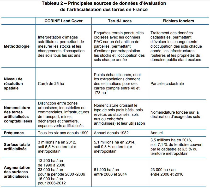
Source Report – Objectif “zéro artificialisation nette” : quels leviers pour protéger les sols ? France Stratégie, 2019.
Artificial land cover in France: key figures and trends
Data from the French Ministry of Agriculture provide an overview of land use in France. Cerema’s data enable us to track the annual flow of ENAF consumption.
Changes in land use in France over recent decades
Artificialized surfaces (in the sense of ENAF consumption) grew almost four times faster than population between 1982 and 2018 in mainland France. While the population grew by only 19% between these two dates, artificial surfaces jumped by 72%, from 2.9 Mha to 5.0 Mha.13. The latest Teruti survey data, published in October 2024, show 5.215 Mha of artificial land in mainland France in 2022.14i.e. 9.5% of the territory (around 550 Mha). In the French overseas departments of Guadeloupe, Martinique, Reunion and Mayotte, the rate of artificialisation varies between 10.8% and 16%. 15
We sometimes hear that this represents “only 9 or 10%”, as if to minimize the problem. In just 40 years (from 1982 to 2022), metropolitan France has urbanized 2.315 Mha (23,150 km²), almost twice the surface area of Ile-de-France (12,012 km²). Given that soil formation takes hundreds or even thousands of years, it’s clear that this dynamic is in no way sustainable.
Recent trends in ENAF consumption in France
According to data produced by Cerema via land files, annual ENAF consumption followed a downward trend from 2011 (31 kha) to 2015 (21 kha), before stabilizing. Only once has it fallen below 20 kha, in 2019 (to 19.5 kha).
ENAF consumption in mainland France (in hectares) 2011-2023
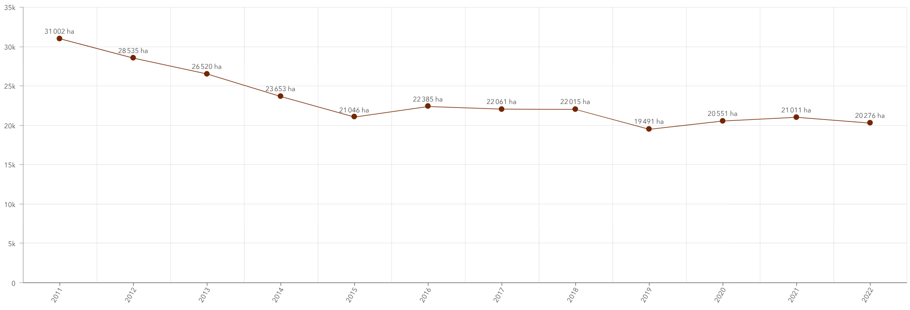
While the French Climate and Resilience Act set a target of halving the rate of artificialisation between 2021 and 2031, compared with the 2011-2021 period, as part of the Zero Net Artificialization (ZAN) objective, no slowdown has yet been achieved.
How France compares with the rest of Europe
Over the period 2000-2018, France is the 3rd most urbanized country in Europe (2,153 km²), behind Turkey (2,864 km²) and Spain (2,474 km²), ahead of Germany (1,380 km²), Poland (1,133 km²) and the UK (1,050 km²).
ENAF consumption in Europe (in km2) 2000-2018
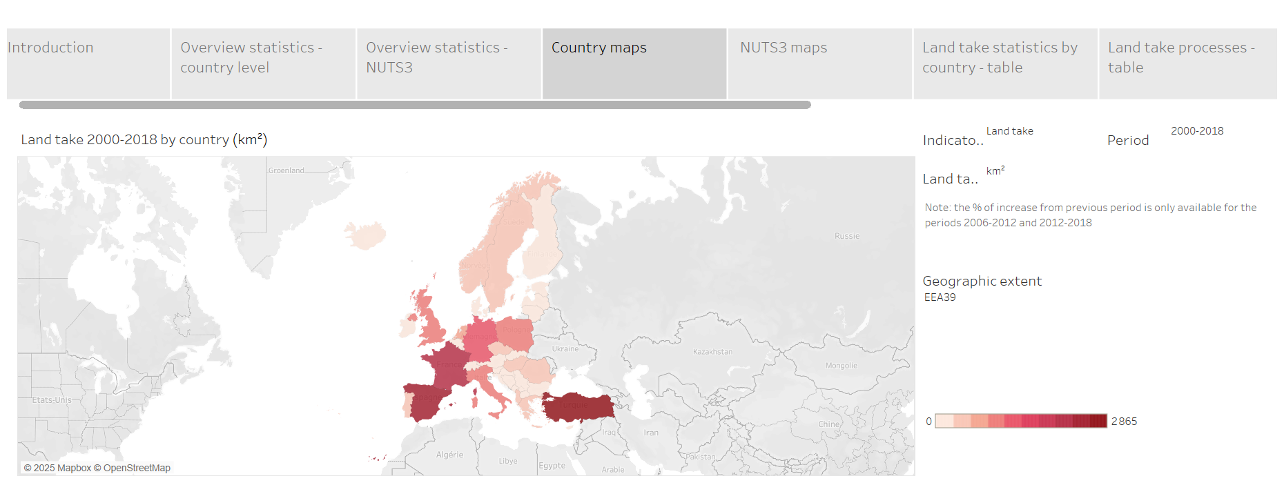
Source Tableau de bord des statistiques de l’artificialisation des sols – Corine Land Cover
In terms of built-up area per capita, France is ahead of comparable countries such as Germany and Italy. On the other hand, these countries have a higher proportion of artificialised land than France, as a percentage of the national territory. For both indicators (artificialization per capita and share of artificialized territory), France is above the European average.
France is above the European average in terms of land artificialisation per capita
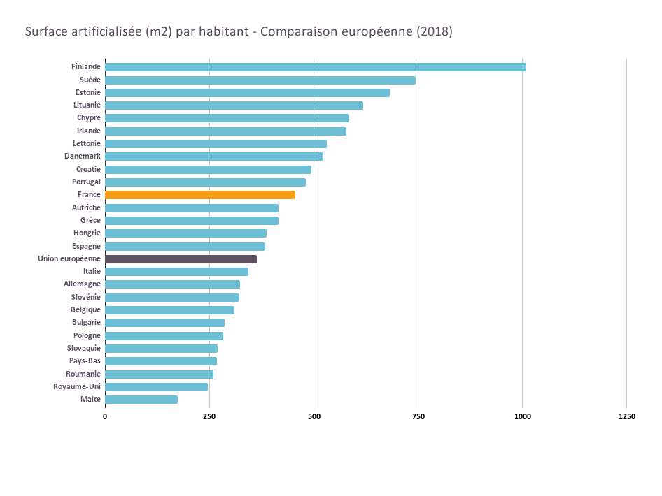
Source Land use – European comparison – Website notre-environnement.gouv.fr
The main drivers of land artificialisation in France
The first – historical – driving force behind soil artificialisation is the industrial revolution and the growing use of fossil fuels, which transformed rural societies into predominantly urban ones.
Some urban planning definitions
Peri-urbanization: Peri-urbanization refers to the expansion of built-up areas on the outskirts of urban agglomerations. The English equivalent is suburbanization. Peri-urbanization is a process of which the peri-urban area is the spatial consequence.
Urban sprawl: Urban sprawl is the simultaneous increase in a city’s surface area and decrease in its population density. It is one of the spatial manifestations of the process of peri-urbanization.
Metropolization: Metropolization refers to the process of concentrating populations, activities and values in large cities. It can occur at the expense of lower-level cities, and often results in the reinforcement of higher levels of the urban hierarchy.
The factors driving metropolization are diverse: economies of scale and agglomeration, comparative advantages, the need for accessibility to networks (on a national and global scale), and so on. The phenomenon of metropolization cannot be reduced to its demographic dimension. It owes its scope and originality to the spatial concentration of strategic functions in the new production system: command and control apparatus; innovation hubs; accessibility to virtual or physical communication networks; cultural attractiveness and weight.
Source These definitions are taken from Géoconfluences, a geography resource site for teachers. See full articles: peri-urbanization, urban sprawl, metropolization
In France, over 75% of the population was rural in 1850.16 In 1982, the proportion was reversed: over 73% of the metropolitan population was urban.17 In 2020, INSEE reports that 93% of the French population lives within the catchment area of a city.18
French rural and urban population trends (as % of total population) 1850-1968
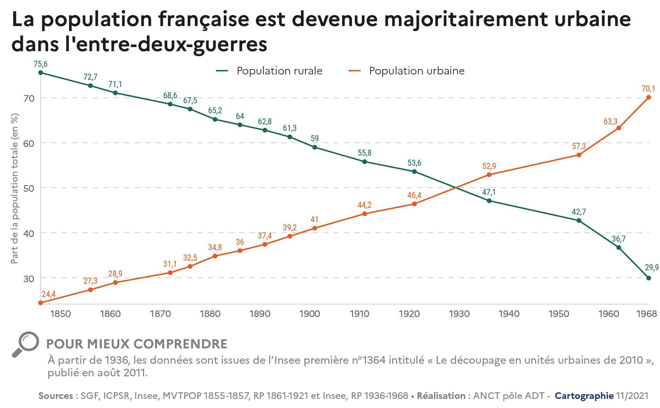
Source D’une France rurale à une France urbaine: les conséquences de l’exode rural, Observatoire des territoires, 2021.
The shift from a largely rural economy to one driven by industry and then services has thus contributed to the expansion of urban areas to accommodate new urban populations.
After the Second World War, aprocess of suburbanization got underway, mainly driven by the mobility possibilities offered by mass access to individual cars, enabling people to de-couple their place of work from their place of residence. In 1939, France had just 1.5 million private cars.19the number of private cars in service reached 2.5 million in 1953, 15.5 million in 1975 and 31 million in 2009.20 and nearly 39 million in 2023.21
Urban sprawl, made possible by the widespread use of private cars, is also encouraged by land price differentials between city centers and suburbs, and more generally between built and unbuilt land. This phenomenon is a major driving force behind land artificialisation.22 This was emphasized by the Conseil des prélèvements obligatoires in a report on La fiscalité locale dans la perspective du ZAN (2022) :
The real deciding factor for a household, a developer or a company in deciding to launch a construction project on an undeveloped area is the price difference between virgin land and land that has already been developed and needs to be rehabilitated.
Finally, on a more general scale, other factors fuel the dynamics of land artificialisation. These include, but are not limited to
- the trend towards metropolization: by concentrating business growth, metropolises have polarized urban and suburban development around them in recent years.23 ;
- increasing household decohabitation24which increases the need for housing;
- the boom in tourism (second homes, dual residences, furnished tourist accommodation reducing the supply of accommodation in town centers);
- or the development of infrastructures: transport, digital (notably data centers) and logistics (notably the large warehouses that are springing up all over the country as e-commerce grows).25
Find out more
- L’artificialisation des sols, Office Français de la Biodiversité
- View NAF land consumption data, Land artificialisation portal
- Analyse de la consommation d’espaces : période du 1er janvier 2009 au 1er janvier 2023, Cerema, May 2024
- Land use in 2022 Teruti 2021-2022-2023 surveys, Agreste, agricultural statistics
The impact of soil artificialization
Land artificialisation is harmful to biodiversity and the climate
Urbanization of natural or agricultural land contributes directly to biodiversity loss
At a local level, soil artificialisation is reflected in the destruction of natural habitats. Soil can be compacted, covered or even sealed. This leads to the alteration of some or all ecological functions, such as habitat provision, water infiltration, pollutant filtration or carbon storage.
On a broader scale, it contributes to the disruption of ecological continuity.26fragmentation of ecosystems and trivialization of environments and landscapes.27 These trends have a particular impact on specialist species – those that need a specific type of habitat (wetland, forest, meadow, etc.) to live, as opposed to so-called generalist species that can be found in a variety of more or less anthropized environments – and therefore lead to a reduction in biodiversity.28
The fragmentation of natural habitats is largely linked to the development of transport infrastructures, which is the result of urban sprawl and urban sprawl.29 Roads and railroads also increase pressure on the ecosystems they cross: noise and air pollution, soil pollution, etc.28
On the climate front, soil artificialisation reduces carbon storage
Soils are a crucial carbon sink: the carbon stock contained in the first 30 centimetres of soil is three times higher than that contained in forest wood.31 Artificialization causes rapid destocking of soil carbon, as a result of development work (earthworks, sealing, etc.).
Replenishing a soil’s carbon stock takes several decades: at a rate of 2 to 3 tCO2/ha.year, soil carbon storage is twice as slow as the removal process that takes place over the twenty years following a change in land use.31
Against a backdrop of unprecedented decline in terrestrial carbon sinks33particularly forest ecosystems in France34the crucial role of soils in the climate system, and the importance of protecting them, must be given greater prominence in public debate.
Achieving Zero Net Artificialization by 2050 – taking into account the difference between the rate of destocking and reconstitution of soil carbon stocks – is therefore a crucial objective if we are to achieve carbon neutrality by the middle of the 21st century.
In addition, urban sprawl and urban sprawl increase the distances involved in compulsory journeys (e.g. home-work), and therefore theCO2 emissions caused by transport.
Water cycle: runoff, floods, droughts, erosion, pollution
The artificialization of soils modifies their structure and composition at depths of several meters or even tens of meters: compaction, use of fill, etc. It also reduces the amount of organic matter and thus the texture of the soil. It also reduces the quantity of organic matter and thus the texture of the soil. This obviously has an impact on water cycles, which can vary according to conditions.
Definitions of the water cycle
The great water cycle: the natural circulation of water on Earth. It is marked by a succession of stages: evaporation, condensation, precipitation, infiltration, passage through natural reservoirs (atmosphere, rivers, lakes, groundwater, glaciers), return to the sea.
The small water cycle: The “small water cycle” refers to the path taken by water from the point of abstraction in the river or groundwater to its discharge into the natural environment. It includes the drinking water circuit and the wastewater treatment circuit. ( OFB )
Watershed: Corresponds to the entire surface area receiving water that flows naturally towards a single watercourse or groundwater table. A watershed is delimited by water divides between different basins. These lines are natural boundaries drawn by the relief: they correspond to ridge lines ( OFB )
Runoff: lateral flow of water that is unable to infiltrate vertically into the soil. Various causes can contribute to runoff: soils rendered less permeable or even impermeable, saturation of already waterlogged soil, excess rainfall compared with the soil’s infiltration capacity, etc.
Evapotranspiration: Evapotranspiration is the process by which the earth’s liquid water is returned to the surrounding atmosphere in gaseous form. This water comes from the sublimation of snow, the evaporation of free water or water contained in the soil, and plant transpiration. ( ONF )
Source Le cycle de l’eau : le voyage de l’eau à travers la Terre, Centre d’information sur l’eau website, and Le grand cycle de l’eau (cycle naturel), Agence de l’Eau Artois-Picardie website. Les fonctions environnementales des zones tampons – protection des eaux (Annexe), CORPEN, 2007. Le pouvoir des arbres : l’évapotranspiration, ONF website.
Artificializing a plot of land results in a sharp rise in runoff and a sharp drop in evapotranspiration. Not all forms of artificialisation have the same impact on rainwater runoff. For example, it has been measured that soil covered with traditional cobblestones allows water infiltration of 50 mm/h, while conventional asphalt road surfaces have infiltration capacities ranging from 0.05 mm/h to 5 mm/h. 28
Comparison of the infiltration capacity of different types of soil (to evaluate different alternative solutions for managing stormwater on a plot).
Reading: in a gravelly soil, water infiltration is excellent. Depending on the size of the gravel, infiltration speed can vary from 3,600 mm/h to 360,000 mm/h.
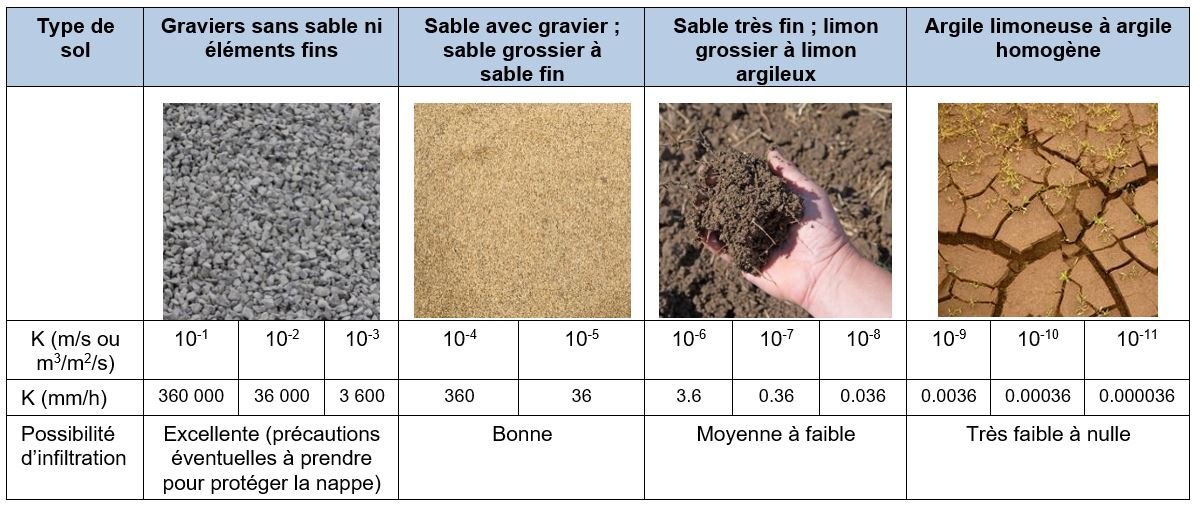
Source Wikhydro
In the scientific literature review published in 2017 by Inra and Ifsttar28the researchers also point out that “the hydrological behavior of green spaces (non-impervious and vegetated areas) in artificial environments is generally very different from that of the initial space”. They point out that the dynamics of infiltration and runoff beneath the soil surface “are more conditioned by the effects of artificialization than by the initial characteristics of the soil”.
These elements shed light on certain French debates concerning the interpretation of the definition of soil artificialisation and the resulting nomenclature of artificialised soils. Given that the definition of soil artificialisation is based on the alteration of its ecological functions, it would be logical to consider as artificialised areas which, although superficially vegetated, present greatly reduced hydric functions.
On a larger scale than the individual plot, i.e. the watershed, land artificialisation modifies water flows. Not only do urban developments increase stormwater runoff, but they also often involve modifying the profile of watercourses and draining wetlands, all of which contribute to accelerating the flow of water, and therefore the speed and force of floods when they occur.
The combination of artificial environments and large impermeable surfaces can lead to flash floods in the event of heavy rainfall in a watershed, devastating infrastructures, activities and residents.
The example of the flood in Valencia (Spain) on October 29 and 30, 2024 illustrates the dramatic nature of these flash floods.37
Urban sprawl has also often led to construction in flood-prone areas. In the Valencia region (Spain), for example, almost a third of the homes affected by the 2024 flood had been built in flood-prone areas since the 2000s. 38
By increasing runoff at the expense of infiltration, soil artificialisation reduces groundwater recharge and reinforces the phenomenon of erosion (through accelerated water movement), which can harm both human activities (loss of agricultural soil, damage to infrastructure, restricted access to areas at risk of landslides, etc.) and biodiversity (erosion of riverbanks, sinking of riverbeds, etc.).
Finally, increased runoff reduces the natural purification of water by the ecosystems in which it normally circulates. As a result, runoff carries with it more pollutants, which contaminate downstream environments.
Reducing artificialization to defend food sovereignty
Most urban sprawl (more than two-thirds) takes place in the following areas39) at the expense of agricultural land. The 20,000 hectares of ENAF consumed each year in mainland France therefore include around 13-14 kha of farmland. In just 40 years (from 1982 to 2022), metropolitan France has urbanized the equivalent of 8.4% of all its remaining farmland (27.7 Mha).
At the same time, France’s population continues to grow, and worsening climate change is threatening agricultural activities and yields (high heat, water stress, extreme weather events, etc.).40
In the coming decades, some areas of France will undergo profound changes in crop types and production methods: it is therefore essential to preserve soil as much as possible throughout the country, to leave as much room for maneuver as possible in the geographical redeployment of agricultural production.41
Urban sprawl and social inequality
The development model of recent decades, based on sprawl and peri-urbanization, has also had harmful consequences from a social point of view.
Dependence on private cars
As mentioned above, the omnipresence of the private car is both the driving force behind urban sprawl and its perpetuation.
Car ownership makes suburbia possible, and suburbia makes car ownership necessary.
The first social consequence of this development model is dependence on the private car, which, although it affects very large sections of French society (75% of French people say they depend on the car to get to work), weighs particularly heavily on the poorest households, against a backdrop of rising fuel prices.
In a 2021 Insee study42the authors showed that the share of disposable income spent on transport rose to 21% for households in the top decile.31 (the most modest), and stood at almost 15% for households up to the 7th decile (11.5% for the wealthiest 10% of households). Since then, transport-related expenses continue to be a major concern for the French: according to an IFOP survey conducted in 2023, the issue of reducing fuel prices “remains by far the most important transport-related issue perceived by the French (60%).”44
Reducing the social mix of cities
At the start of the peri-urbanization movement, growing access to individual cars largely contributed to reducing the social mix of cities, by enabling those who could afford it to choose a place to live that was separate from their place of work.45in a form of “competition for space”.46 The possibility of commuting47 has increased socio-spatial segregation.
The suburban model at the heart of poor housing and urban sprawl
Houses built in the suburbs can also be of uneven quality. According to the note by the Fabrique écologique Réparer la ville: pour une régénération des lotissements (2019), the challenges of fuel poverty in the suburbs are linked in particular to the use of “poor quality” building materials. These concerns coincide with urban planner Sylvain Grisot’s analysis of the land-consuming “pavillonnaire model”. He points out that the corollary of this standardized housing production model is urban sprawl – that it is a cause and not simply a coincidence – since “the only sites capable of accommodating repetitive production that is difficult to adapt to complex urban contexts [are] agricultural land on the edges of towns”.48
In this suburban model, the constraints of mobility and therefore access to services and shops, added to the problems linked to the quality of the buildings, lead to significant expenses and can complicate the resale of properties that are less sought-after on the market, most often owned by modest households.49
Less access to public services
Finally, the extension and maintenance of networks (electricity, water, sewage) represent an additional burden for local authorities. Urban sprawl and the development of low-density residential areas also complicate the provision of public transport services (as well as access to services and shops), while at the same time making residents dependent on private cars.
Conclusion
Far from being just the floor of our lives, soils are ecosystems in their own right, a three-dimensional environment as complex as it is fascinating and fragile. The ecological functions performed by soils are essential for the entire terrestrial ecosystem, and therefore for the life of human societies: without the ecological functioning of soils, there can be no economic functioning of society.
This is why soil artificialisation is a vital ecological issue – our lives depend on soil – and a central one – none of our activities can do without soil. And yet, soil artificialisation has increased sharply in recent decades, contributing not only to the collapse of biodiversity, but also to the reduction of carbon sinks and the increase in greenhouse gas emissions, the disruption of water cycles and the erosion of our food sovereignty. Finally, the territorial dynamics (peri-urbanization, metropolization) that determine soil artificialisation also contribute to the growth of socio-spatial inequalities.
Find out more
Tools and proposals to preserve soil
- MUSE report: Integrating soil multifunctionality into urban planning documents, ADEME – Cerema, 2022
- Objectif ” zéro artificialisation nette ” : quels leviers pour protéger les sols, France Stratégie, July 2019
- MOOC Land Sobriety: my territory in action, CERDD
- MOOC Sustainable cities and territories: methods and tools for taking action, ADEME-CNFPT
- Pedogenesis: Soil formation and evolution. ↩︎
- In reality, there are finer distinctions in soil structure (structural horizons, reductive horizons, vertic horizons, etc.). See Pédologie – Les différents types de sol – Course by Jacques Beauchamp on the Université de Picardie website. ↩︎
- See Sols artificialisés et processus d’artificialisation des sols: déterminants, impacts et leviers d’action, INRA, 2017 (page 400). ↩︎
- See Classification par taille des organismes du sol, Supagro, consulted on 16/01/25. ↩︎
- See Quentin Vincent, Apolline Auclerc, Corinne Leyval, La biodiversité des sols, Encyclopédie de l’environnement, 2023. ↩︎
- If soils are unable to sufficiently infiltrate water from precipitation, runoff reinforces the erosion of river banks, influencing their shape and the speed of water flow. ↩︎
- See Objectif “zéro artificialisation nette” : quels leviers pour protéger les sols, France Stratégie, 2019. ↩︎
- Law no. 2021-1104 of August 22, 2021 on combating climate disruption and strengthening resilience to its effects, Article 194-III-5°. ↩︎
- Decree no. 2023-1096 of November 27, 2023 on the evaluation and monitoring of soil artificialisation. ↩︎
- Lucas: Land Use/Cover Area frame statistical Survey. ↩︎
- Cerema is a public body that “supports the State and local authorities in drawing up, implementing and assessing public development and transport policies”. ↩︎
- See Les modes d’occupation du sol : exemple du MOS Île-de-France, Portail de l’artificialisation des sols, consulted on 16/01/25. ↩︎
- Source: L’occupation du sol entre 1982 et 2018, Agreste, Les Dossiers, 2021. ↩︎
- Source: L’occupation du territoire en 2022 Enquêtes Teruti 2021-2022-2023, Agreste, la statistique agricole, 2024. Please note that the survey methodology was modified in 2024. Long series of data prior to the methodological change (1982-2022) are available online. ↩︎
- Source: Territoire et climat. Land use, Graph’Agri 2024, Agreste, agricultural statistics. ↩︎
- Source: D’une France rurale à une France urbaine : les conséquences de l’exode rural, Cahier territoires et transitions n°1, Observatoire des Territoires, 2021. ↩︎
- Source: L’urbanisation en 1982 : les résultats du recensement, Economie et statistiques, 1983. ↩︎
- Source: In France, nine out of ten people live in a city’s catchment area, Insee Focus, 2020. ↩︎
- Source: Abel Chatelain, L’industrie automobile française, Géocarrefour, 1950. ↩︎
- Source: L’industrie automobile en France depuis 1950, L’économie française, 2009 edition, Insee. ↩︎
- Source: 38.9 million cars on the road in France on January 1, 2023, Données et études statistiques, Ministry of Ecology, 2023. ↩︎
- See Objectif “zéro artificialisation nette” : quels leviers pour protéger les sols ? France Stratégie, 2019. ↩︎
- Cerema refers to metropolization as a “driving force” behind land artificialisation. See : Cerema, L’artificialisation et ses déterminants d’après les Fichiers fonciers, April 2020. ↩︎
- The term “decohabitation” refers to the fact that household size is shrinking, either as a result of divorce, or because young people are leaving their parents’ home. This has been a fundamental trend over the last few decades, and is a major determinant of housing demand. See Une baisse continue du nombre de personnes par logement depuis 20 ans – Insee Flash Languedoc-Roussillon, 2015. ↩︎
- It’s possible to make a success of ZAN and reduce inadequate housing!Fondation pour la Nature et l’Homme – Fondation Abbé Pierre, 2024. ↩︎
- Ecological continuity is defined as “a set of environments that are sufficiently well connected to be used by species to carry out their life cycle”(Encyclopédie de l’environnement). Maintaining and restoring terrestrial and aquatic ecological continuity is one of the fundamental dimensions of the “Trame verte et bleue”, a public policy launched in 2007 to take greater account of biodiversity in regional planning (see La Trame verte et bleue, on the Inventaire national du patrimoine naturel website). ↩︎
- That is, the disappearance of remarkable habitats, on which certain species, known as specialists, specifically depend, and the transformation of rare environments into more ordinary ones. See for example, Christine Acerbi, Nicolas Cornet, Banalisation des milieux naturels franciliens: des outils et des réponses adaptés, Institut Paris Région, 2017. ↩︎
- Summary of the collective scientific expertise: Artificialized soils and soil artificialization processes: determinants, impacts and levers for action, INRA-IFSTTAR, 2017. ↩︎
- Urban sprawl is the term used to describe situations where urban development does not take place in a continuous pattern, but rather in a “confetti” pattern across the countryside, gradually fragmenting agricultural and natural areas. See the detailed definition of urban sprawl on the Géoconfluences website. ↩︎
- Summary of the collective scientific expertise: Artificialized soils and soil artificialization processes: determinants, impacts and levers for action, INRA-IFSTTAR, 2017. ↩︎
- Plans locaux d’urbanisme – Des arguments pour agir en faveur du climat, de l’air et de l’énergie, Cerema, 2018. ↩︎
- Plans locaux d’urbanisme – Des arguments pour agir en faveur du climat, de l’air et de l’énergie, Cerema, 2018. ↩︎
- Fabrique de savoirs – The unprecedented decline of the earth’s carbon sink, CEA, 2024. ↩︎
- Annual Report 2024, Executive Summary, Haut Conseil pour le Climat, 2024. ↩︎
- Summary of the collective scientific expertise: Artificialized soils and soil artificialization processes: determinants, impacts and levers for action, INRA-IFSTTAR, 2017. ↩︎
- Summary of the collective scientific expertise: Artificialized soils and soil artificialization processes: determinants, impacts and levers for action, INRA-IFSTTAR, 2017. ↩︎
- See, for example, Les inondations en Espagne à Valence vues du ciel, des images de désolation, HuffPost (31/10/24). ↩︎
- Devastating floods in Valence: revealing high vulnerability in a Mediterranean context, Géoconfluences (13/11/2024). ↩︎
- Source: Les enjeux de l’artificialisation des sols : diagnostic, Comité pour l’économie verte, 2018. ↩︎
- Source: Agriculture et climat : l’urgence de s’adapter, Carbone 4, 2023. ↩︎
- Source: Analysis of crop resilience in an agro-climatic context. Carbone 4, 2024. ↩︎
- Source: Insee, In 2017, households spent 11% of their disposable income on cars – Insee Première, 2021. ↩︎
- Plans locaux d’urbanisme – Des arguments pour agir en faveur du climat, de l’air et de l’énergie, Cerema, 2018. ↩︎
- Observatory of shared and electric mobility, IFOP, 2023. ↩︎
- DDT de l’Oise, Les cahiers de l’Oise, Controlling the adverse effects of urban sprawl , 2006. ↩︎
- Marc Wiel, Temps gagné, temps perdu: les pièges de la vitesse, Économie & Humanisme, 2002. ↩︎
- In other words, travel between home and work. ↩︎
- Sylvain Grisot, Manifesto for circular urbanism: for concrete alternatives to urban sprawl Editions Apogées, 2021. ↩︎
- See the France 2 documentary: Le monde en face, Rêve pavillonnaire, les dessous d’un modèle , 2019. ↩︎